Puerto Vallarta
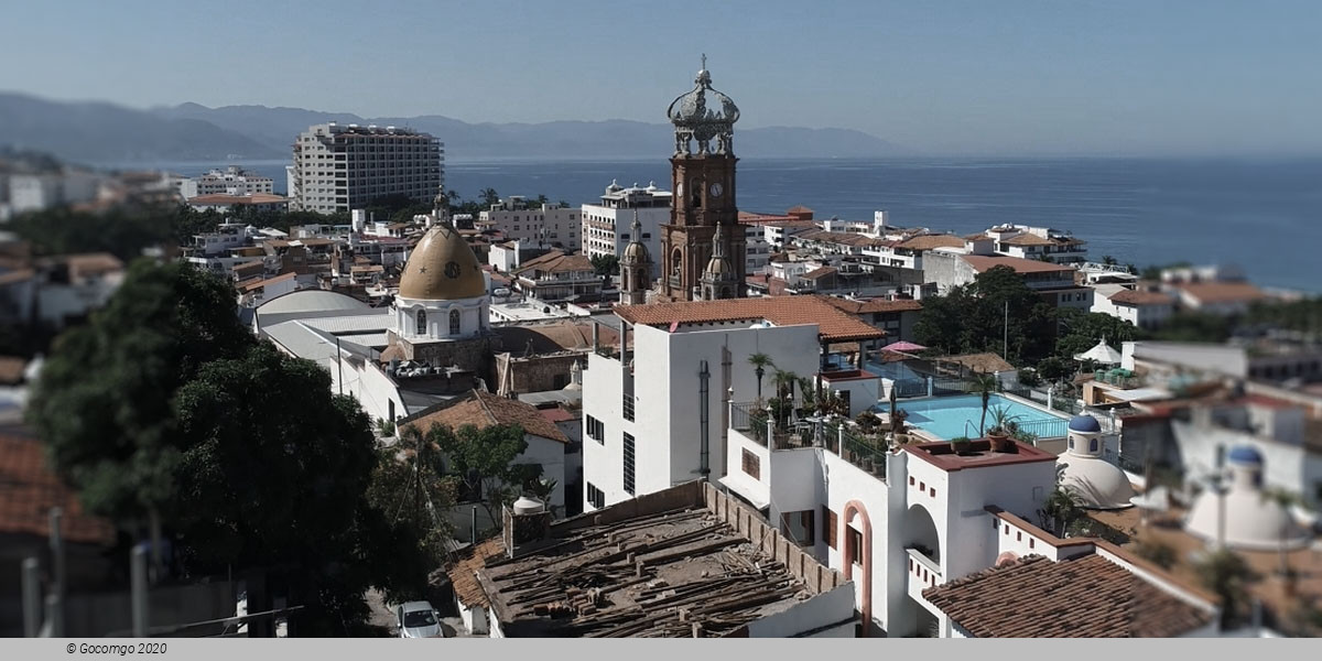
Puerto Vallarta is a Mexican beach resort city situated on the Pacific Ocean's Bahía de Banderas in the Mexican state of Jalisco. PV is the second largest urban agglomeration in the state after the Guadalajara Metropolitan Area. The City of Puerto Vallarta is the government seat of the Municipality of Puerto Vallarta which comprises the city as well as population centers outside of the city extending from Boca de Tomatlán to the Nayarit border (the Ameca River). To the north, it borders the southwest part of the state of Nayarit. To the east, it borders the municipality of Mascota and San Sebastián del Oeste, and to the south, it borders the municipalities of Talpa de Allende and Cabo Corrientes.
History
Puerto Vallarta's proximity to the Bay of Banderas, the agricultural valley of the Ameca River, and the important mining centers in the Sierra have given the town a more interesting past than most Mexican tourist destinations. Puerto Vallarta was a thriving Mexican village long before it became an international tourist destination. Tourism is a major economic activity because of the climate, scenery, tropical beaches, and rich cultural history.
Pre-Hispanic times to the 19th century
Few details are known about the history of the area prior to the 19th century. There is archaeological evidence to suggest continuous human habitation from 580 BC, and similar evidence (from sites near Ixtapa and in Col. Lázaro Cárdenas) that the area belonged to the Aztatlán culture which dominated Jalisco, Nayarit and Michoacán from c. 900–1200. The limited evidence in occidental Mexican archeology have limited the current knowledge about pre-historic life in the area.
Spanish missionary and conquistador documents chronicle skirmishes between the Spanish colonizers and the local peoples. In 1524, for example, a large battle between Hernán Cortés and an army of 10,000 to 20,000 Indians resulted in Cortés taking control of much of the Ameca valley. The valley was then named Banderas (flags) after the colorful standards carried by the natives.
Also the area appears on maps and in sailing logs as a bay of refuge for the Manila Galleon trade as well as for other coastal seafarers. As such it figures in some accounts of pirate operations and smuggling and pirate contravention efforts by the viceregal government. During the 17th and 18th centuries the Banderas Valley and its beaches along the Bay of Banderas served as supply points for ships seeking refuge in the bay. The area also served as a point where smuggled goods could be sent on to the Sierra towns near Mascota, evading the customs operations at San Blas, Nayarit.
El Carrizal and Las Peñas - 19th century
During the 19th century the history of Puerto Vallarta, then called El Carrizal or Las Peñas, was linked to the history of the Sierra towns of San Sebastián del Oeste, Talpa de Allende and Mascota. While today these towns are considered quaint tourist destinations, during much of the 18th century, Mascota was Jalisco's second largest town, after Guadalajara. Mascota and its neighboring towns located in the high plateaus of the Sierra, developed as agricultural towns to support the growing mining operations in the Sierra.
During the 18th century, as Mascota grew, Puerto Vallarta grew with it, transforming itself from a small fishing and pearl-diving village into a small beach-landing port serving the Sierra towns. At the time the main port serving Jalisco was located at San Blas, but the inconvenient overland route from San Blas to the Sierra towns made Puerto Vallarta a more convenient alternative for smaller shipments, not to mention smuggling operations which evaded the tax collectors at San Blas. Puerto Vallarta also became a vacation destination for residents of the Sierra Towns, and by the mid 19th century, the town already had its regularly returning population of vacationers. Most of the early settlers in Puerto Vallarta were families who had left the Sierra towns for one reason or another.
1859 saw an important turning point for the small village, then known as Las Peñas. That year the Union en Cuale mining company took possession of land extending from Los Arcos to the Pitillal river and extending back up into the Sierra for kilometres. The Union en Cuale company was owned in part by the Camarena brothers of Guadalajara who had developed a small trade in oil palm in Las Peñas. The purpose of the government's sale of the land to the company was to provide for shipping, fishing and agricultural support for the mining operations which were growing quite quickly in the Sierra.
The official founding story of Las Peñas and thus of Puerto Vallarta is that it was founded by Guadalupe Sánchez Torres, on 12 December 1851, as Las Peñas de Santa María de Guadalupe. Unfortunately the record of Sr. Sanchez's purchase of property in Las Peñas dates the sale to 1859. Also even as early as 1850 the area was already peopled by fishermen, pearl divers, smugglers and foragers, all of whom had something of a permanent existence in the area. Given the existing historical documents it is simply impossible to date the first permanent settlement in the area,
There is however no doubt the development of Las Peñas into a self-sustaining village of any significant size happened in the 1860s as the mouth of the Cuale area was exploited to support the operations of the newly enfranchised Union en Cuale company. As such 1859 marks the beginning of Puerto Vallarta as a village. Twenty years later, by 1885, the village comprised about 250 homes and about 800 residents.
The early municipality - early 20th century
In 1918, the village was elevated to municipality status and renamed after former state governor Ignacio Vallarta. During the early years of the 20th century, most of Puerto Vallarta was owned by the Union en Cuale company controlled by the American Alfred Geist. Geist sold land only in large plots at prices that were quite high for the time and otherwise leased the land on short-term leases. To remedy this situation and to enable the new municipality to develop, the citizens petitioned the government for a land grant based on the new constitution's provisions.
In 1921, the Local Agrarian Commission approved a grant of some 9,400 hectares (23,000 acres; 36 square miles), with the land to be expropriated from the Union en Cuale company. The grant was established as an ejido holding (a farming cooperative administered by the government). Legal squabbling over the size of the land grant, and the ejido status of the properties involved would stymie growth in Puerto Vallarta into the 1960s, as developers were reluctant to build anything too substantial on land for which one could not obtain clear title. (Ejido land is controlled by individuals who are given licenses to use it, but it could not be sold, subdivided or leased.)
During the Cristero War, the municipality was twice taken over by Cristero forces (April 1927 and January 1928). After it was recaptured for a second time, the national government stationed a small garrison there under Major Ángel Ocampo. The garrison was stationed near the mouth of the Cuale River and is responsible for planting many of the palms that now line the beaches near the mouth of the Cuale River to help limit beach erosion during heavy rains in October 1928. One casualty of the skirmishes was local pastor Padre Ayala who was exiled to Guadalajara for his role in fomenting the local revolt. He died there in 1943, though his remains were returned 10 years later and interred in the main parish church of Our Lady of Guadalupe.
As mining activities in the Sierra waned in the early years of the 20th century, Puerto Vallarta and the agricultural valley to the north of the city became important destinations for those leaving the Sierra towns and looking for a place to settle. Many of those who arrived had family members already living in Puerto Vallarta, and the pattern of migration that ensued turned the town into a collection of more or less extended families, giving it the cohesion of a typical sierra town.
From 1925 until 1935, the Montgomery Fruit Company operated in the area around Ixtapa. Friction with the state government over labor issues eventually led to the venture being abandoned, but for ten years it provided an important source of employment in the area.
The first airplane service arrived in 1932, with electrical service on a small scale arriving about the same time. The first suspension bridge over the Cuale went up in 1933. The city's first plumbing system was started in 1939. In 1942, Puerto Vallarta was finally connected by road to Compostela, Nay. Until then the only access to Puerto Vallarta was by sea, air, or by mule trails to the sierra towns. Also in 1942, in the New York-based magazine Modern Mexico the first advertisement for a Puerto Vallarta vacation appeared, sponsored by the Air Transport Company of Jalisco. By 1945, the company was landing DC-3s in Puerto Vallarta (carrying 21 passengers).
By the 1950s, Puerto Vallarta had started to attract Americans, mostly writers and artists in search of a retreat from the USA of the era of Eisenhower and McCarthy. Gringo Gulch began to develop as an expatriate neighborhood on the hill above the Centro. The city also attracted Mexican artists and writers who were willing to trade the comforts of life in the larger cities for its scenic and bucolic advantages.
In 1956, the Mascota mule trail was replaced by a packed dirt road. In 1958, 24-hour electrical generation arrived. A new airport arrived in 1962 connecting Puerto Vallarta with Los Angeles via Mazatlán, and the Mexican Aviation Company began offering package trips.
By the early 1960s, the population had started to spread beyond the Centro and Gringo Gulch, and the Colonias of 5 Diciembre (north of the Centro) and Emiliano Zapata (south of the Cuale River) began to grow.